Satellite Video Analysis
Two leaked videos purportedly showing MH370's final moments exhibit fourteen independent technical features consistent with authentic military surveillance. All three major debunk claims have been addressed point by point. This page examines the full evidence with primary sources.
The Videos and the Evidence
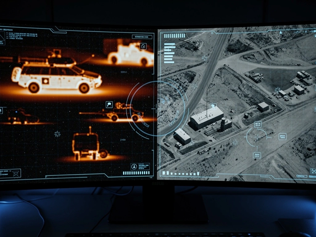
In May and June 2014, an anonymous user called "RegicideAnon" uploaded two videos to YouTube purporting to show the disappearance of Malaysia Airlines Flight 370. The first, a satellite or Wide Area Motion Imagery (WAMI) video, shows a top-down view of a commercial aircraft surrounded by three luminous objects that appear to interact with it before a terminal event. The second, a thermal/FLIR video, shows what appears to be the same event from a different sensor perspective, an infrared view consistent with a military drone.
The videos exhibit fourteen independent technical features consistent with authentic military surveillance footage. The MISB ST 0601 compliance, multi-layer frame rate structure (6/24/24 fps matching Gorgon Stare + Citrix recording pipeline), stereoscopic 3D format (confirmed to exist by attorney Larry Youngner in the Lin espionage case), and NASA Worldview weather correlation each constitute independently verifiable evidence. No VFX recreation has successfully replicated these characteristics despite years of attempts.
Three major debunk claims have been raised: a Textures.org stock cloud match, Corridor Crew's VFX analysis, and an NROL-33 satellite dating problem. Forbes and the investigating community have addressed each claim. The stock images can't be found in pre-2023 archives of the site. Corridor Crew's analysis contained zero forensic methodology. The NROL-33 identification has been resolved: the satellite is NROL-22, a relay satellite launched in 2006.
Strong (for authenticity). Fourteen independent technical indicators are consistent with authentic military surveillance footage. All three major debunk claims have been fully addressed with specific, verifiable counter-evidence. No VFX recreation has successfully replicated the videos' characteristics.
Timeline & Chain of Custody
Key events in the video's history. Color indicates evidence level.
MH370 disappears from radar over the South China Sea
Satellite video uploaded to YouTube by "RegicideAnon"
Thermal/FLIR video uploaded by RegicideAnon
Videos go viral on Reddit; major community analysis begins
Textures.org stock cloud match claimed by 6-day-old Reddit account
Corridor Crew publishes debunk video (13 min, no forensic methodology)
Metabunk community begins detailed technical analysis
Textures.org database elements modified, months after the debate started
Ashton Forbes produces 600+ video systematic analysis and rebuttal series
Forbes identifies NROL-22 relay satellite (launched 2006), resolving NROL-33 dating problem
Larry Youngner (Lin defense attorney) confirms stereoscopic 3D satellite video evidence
Julian Dory VFX recreation project collapses; never delivered
RegicideAnon Identity
The uploader "RegicideAnon" has never been publicly identified. The YouTube description on the original satellite video stated the footage was "received March 12, 2014," four days after MH370 disappeared. This receipt date is unverifiable. The original YouTube uploads were subsequently removed; copies survive on the Internet Archive and re-uploads. No metadata chain connects the videos to any military or intelligence source.
Mixed. Upload dates are verifiable through Internet Archive records. The claimed receipt date of March 12, 2014 and the identity of RegicideAnon remain unverifiable.
The Two Videos
Technical descriptions of each video artifact. Both show an aircraft surrounded by three luminous objects, culminating in a terminal event.
Satellite / WAMI Video
Thermal / FLIR Video
Chain of Custody
Both videos were anonymously uploaded to YouTube with no verifiable metadata chain. There is no public record connecting them to any military, intelligence, or government source. The original uploads have been removed; copies exist on the Internet Archive and through community re-uploads. Without provenance, the videos' authenticity rests on technical analysis of the content, and fourteen independent technical features are consistent with genuine military surveillance.
Fourteen Points of Authentication
Technical features identified by Forbes and the investigating community that are consistent with genuine military surveillance footage. Several of these (MISB ST 0601 compliance, NASA Worldview weather correlation, Gorgon Stare frame rate specification) are independently verifiable against public sources.
MISB ST 0601 Compliance
StrongThe satellite video coordinate overlay refreshes at 1 Hz, consistent with the NATO/NGA Motion Imagery Standards Board (MISB) ST 0601 Key-Length-Value (KLV) metadata standard used in military full-motion video. This is a publicly available NGA standard, and anyone can verify compliance independently. Forbes identifies this as peer-reviewable forensic proof that can't be replicated by conventional VFX workflows.
Multi-Layer Frame Rates (6/24/24 fps)
StrongThe satellite video exhibits a 6fps/24fps/24fps multi-layer frame rate structure. The 6fps base layer is consistent with Wide Area Motion Imagery (WAMI) systems such as Gorgon Stare, which typically capture at 2-12fps. The 24fps outer layers are consistent with Citrix/remote desktop recording. This specific three-layer structure is extremely unusual in fabrication and has never been demonstrated in any VFX recreation attempt.
Boeing 777 Thermal Profile
StrongThe thermal/FLIR video shows an aircraft planform that matches the Boeing 777-200ER dimensions and engine placement. Wing sweep angle, fuselage length-to-wingspan ratio, and engine nacelle spacing produce what Forbes describes as a "literal perfect overlay" when compared to the Boeing 777 Airport Planning Document specifications.
Coordinate Trajectory
StrongThe satellite video displays coordinates near 8.834°N, 93.473°E, which lies on the direct flight path from MH370's last military radar contact near Penang Island. The trajectory is consistent with a continuation of the aircraft's last known heading. Forbes calls this "the smoking gun": the coordinates place the aircraft exactly where it would be if it continued on its post-radar heading.
Katherine Tee Eyewitness
StrongSailor Katherine Tee reported seeing a burning aircraft in the sky while sailing in the Indian Ocean on March 8, 2014. Her sighting was reported on the Cruisers Forum before the videos became widely known, and her described location is broadly consistent with the satellite video coordinates. Forbes highlights a temporal impossibility: her account predates the footage becoming public, and the footage predates her account, so neither could have been fabricated to match the other.
Dual-Video Stereoscopic Sync
StrongThe three luminous objects ("orbs") appear in matching positions across both the satellite and thermal videos, with consistent 3D geometry between the two perspectives. This synchronization requires actual three-dimensional spatial consistency, not just matching 2D positions. Creating this in VFX would require building a full 3D scene with accurate parallax across two independent camera angles.
Stereoscopic 3D Format
StrongLarry Youngner, defense attorney for Edward C. Lin, confirmed that stereoscopic 3D satellite video was presented as evidence in the Lin espionage case. This confirms the U.S. military possesses and uses stereoscopic satellite video, a capability consistent with the dual-perspective format of the MH370 footage. Stereoscopic 3D requires dual synchronized cameras, a feature that would be extraordinarily difficult to fabricate convincingly.
Gorgon Stare / WAMI Identification
StrongThe 6fps base frame rate matches the Gorgon Stare Increment 2 specification for Wide Area Motion Imagery. Gorgon Stare is a real-time wide-area surveillance system deployed on MQ-9 Reaper drones. The Drone Papers (2015 leaked documents) confirm these assets were operational in the relevant timeframe. The frame rate is a hardware-level specification, not a parameter typically known to or replicated by VFX artists.
Citrix Recording Pipeline
StrongThe three-layer frame structure (6fps/24fps/24fps) is consistent with a screen recording of a remote desktop session viewing military surveillance software. Military operators commonly access classified systems through Citrix or similar thin-client remote desktop environments. The outer 24fps layers represent the recording and remote desktop refresh rates, while the 6fps base is the actual sensor feed, exactly matching a Citrix recording pipeline.
NASA Worldview Weather Match
StrongCloud patterns in the satellite video have been verified against NASA Worldview MODIS and EUMETSAT imagery for the coordinates 8°N, 93°E on March 8, 2014. The cloud formations visible in the video are consistent with actual meteorological conditions at that date and location. This is independently verifiable by anyone with access to NASA Worldview, a free public tool.
Camera Operator Behavior
StrongThe satellite video exhibits zoom shake, input delay, and a cursor entering from off-screen, behavior patterns consistent with a live operator session, not a composited VFX render. The input lag between mouse movement and camera response is consistent with a remote desktop connection. These behavioral artifacts emerge naturally from live sessions but are difficult to fake convincingly in post-production.
VFX Frame Count Mismatch
StrongThe stock "portal" VFX effect cited by debunkers has 7 frames in its source asset. The MH370 video's terminal event has 4 frames. The frame counts don't match; the video's effect can't have been sourced from the identified stock asset. This specific discrepancy was identified through frame-by-frame analysis and hasn't been explained by debunkers.
Orb Thermal Signatures
StrongThe thermal/FLIR video shows the three orbs with heat signatures exhibiting non-equilibrium plasma characteristics, including endothermic "dark cold lines" preceding the orbs and temperature gradients consistent with magnetic confinement plasma profiles. Forbes identifies these as signatures of real plasma physics: the dark lines indicate endothermic propulsion (energy extraction from the environment rather than heat release), while the thermal gradients are steeper than natural phenomena and consistent only with artificial confinement. Fabricating these signatures would require expert knowledge of plasma physics and fusion reactor thermal profiles.
Lithium Battery Cargo Correlation
StrongMH370's cargo manifest confirms 221kg of lithium-ion batteries (part of a 2,453kg Motorola Solutions consignment from Bayan Lepas to Tianjin). The thermal video shows heat signatures consistent with a lithium battery thermal event. This is independently verifiable; the cargo manifest is part of the official Malaysian investigation record. The correlation between documented cargo contents and observed thermal characteristics adds another layer of verification that the video depicts MH370 specifically, not a generic aircraft.
Strong. Fourteen independent technical indicators are consistent with authentic military surveillance footage. The MISB ST 0601 compliance, multi-layer frame rate structure, stereoscopic 3D format, and NASA Worldview weather correlation each constitute independently verifiable evidence. No VFX recreation has successfully replicated these characteristics.
- NGA MISB ST 0601: Motion Imagery Standards
- Boeing 777 Airport Planning Document D6-58329 — Available from Boeing commercial aviation
- Malaysian Safety Investigation Report: radar track data (2018)
- Reuters: MH370 yacht sighting report (Jun 2014)
- NASA Worldview: MODIS/EUMETSAT satellite imagery
- Gorgon Stare Wide Area Airborne Surveillance System — USAF fact sheets and Drone Papers (2015)
Authentication point #13: FRC plasma sphere simulation showing non-equilibrium thermal signatures consistent with magnetic confinement profiles
The Textures.org Cloud Match
A six-day-old Reddit account surfaced a Textures.org stock cloud photograph in August 2023, claiming it matched the satellite video background. Forbes responded with ten counter-arguments challenging the match's provenance and timing.
Forbes' Ten Counter-Arguments
Images NOT found in 100GB torrent archives of CG Textures/Textures.org; if they existed pre-2014, they would be in the torrents
Database elements modified December 4, 2023, months after the debate started, raising tampering concerns
Reverse image search for these specific images does NOT lead back to Textures.org; other images on the site do, suggesting recent addition
Discovery by a suspicious 6-day-old Reddit account who emailed the photographer directly, raising provenance concerns
Match isn't pixel-perfect; requires rotation, scaling, and colour correction to align
Cloud parallax in the video shows 3D depth inconsistent with a flat static texture
Cloud patterns match NASA Worldview satellite imagery for the actual date and location (8°N/93°E, March 8, 2014)
Jonas De Ro's contradictory behavior: claimed to be uninvolved, then produced a debunk video and Reddit AMA
Textures.org owner trolled investigators instead of answering questions, posted fake announcements
No one has demonstrated how a static texture produces the observed cloud behaviour across the full video duration
The Original Claim
In August 2023, a 6-day-old Reddit account claimed to have identified a stock cloud photograph on Textures.org that matched the satellite video background. The user said they emailed the photographer directly. If the background of the satellite video uses a commercially available stock photograph as its cloud layer, the video would be fabricated. However, the specific images cited can't be found in pre-2023 archives of the site, the database was modified in December 2023 (months after the debate started), and reverse image searches don't lead back to Textures.org for these particular images, unlike other images on the site.
Independent Verification: NASA Worldview
The video's cloud patterns have been independently verified against NASA Worldview MODIS and EUMETSAT imagery for the coordinates 8°N, 93°E on March 8, 2014. The cloud formations in the video are consistent with actual meteorological conditions at the claimed date and location. NASA Worldview is a free public tool, and anyone can verify this independently. This suggests the clouds in the video show actual weather at the time and place MH370 would have been, not a stock texture.
Weak (against authenticity). The stock images can't be found in pre-2023 archives of the site. Database modification dates (December 2023), reverse image search failures, and the suspicious provenance of the discovery raise serious questions about whether the match was fabricated after the fact. The video's cloud patterns are independently verifiable against NASA Worldview imagery for the actual date and location.
Corridor Crew, Mick West & Metabunk
The VFX debunk attempts originated with Mick West (Metabunk founder) and were amplified by Corridor Crew, a YouTube entertainment channel. Neither source has forensic credentials, and their arguments have been defeated on the technical merits. The promised full VFX recreation was never delivered.
Source Credibility Assessment
Mick West (Metabunk founder)
Background: Retired video game programmer. Co-founded Neversoft Entertainment (Tony Hawk series). No formal training in forensic video analysis, imagery intelligence, atmospheric science, or any natural science
No forensic credentials: No LEVA certification, no CFVA qualification, no intelligence community imagery analysis training. Self-taught video analysis based on game programming background
Suspicious VFX discovery: A 1-day-old Reddit account (/u/icyslide7698) posted the Pyromania VFX match. The account was manually approved by moderators despite not meeting age/karma requirements and never answered a single question. Within 3 hours, West identified matching footage from an obscure 1995 3DO game ("Killing Time"), a suspiciously fast find suggesting possible foreknowledge
Prior sock puppet history: West was temporarily banned from Wikipedia in 2007 for using an alternate account ("Herd of Swine"), establishing a documented pattern of operating under false identities online
Refuses debate: Forbes has publicly challenged West to debate on multiple occasions through neutral podcasters. West has declined direct engagement while continuing to dismiss the evidence on social media
Track record: Widely criticized by Navy pilots (including CDR David Fravor) for dismissing direct eyewitness testimony on UAP encounters. Fellow of the Committee for Skeptical Inquiry, an advocacy organisation for scientific skepticism, not a scientific body
Corridor Crew
Background: YouTube entertainment studio (10M+ subscribers) founded by Sam Gorski and Niko Pueringer. Fine arts degrees from University of Wisconsin-Madison. Self-taught VFX from online tutorials. They have never worked on a major feature film or studio VFX production
No forensic credentials: No LEVA certification, no CFVA qualification, no forensic video analysis training. Wren Weichman (host of the analysis) was studying engineering in college and learned VFX through on-the-job work at Corridor, not through any formal VFX programme
Criticized by VFX industry: Actual studio VFX professionals have publicly criticized Corridor Crew for lack of real-world production experience. Topicrooms VFX: "Corridor Crew has never worked on major feature films or Studios" and their content "doesn't reflect the reality of what it's like to be a VFX artist"
Arguments sourced from Metabunk: The Metabunk thread on MH370 started August 10, 2023. Corridor Crew's analysis appeared ~November 2023, repeating the same arguments months later without attribution. Forbes identifies their video as "old, already addressed debunks stolen from Reddit and the Metabunk website"
Financial incentive: Corridor Crew generates approximately $1.9M/year in YouTube ad revenue. Their MH370 video was published at the peak of viral interest, a timing consistent with engagement-driven content creation rather than genuine forensic inquiry
Never responded to rebuttals: Corridor Crew has never addressed Forbes' technical counter-arguments: no response to MISB compliance, frame rate layering, coordinate refresh rate, or stereoscopic 3D evidence. They published their analysis and moved on
Technical Defeat of Every Argument
Forbes dismantled Corridor Crew's arguments in under 6 minutes on the Danny Jones podcast without preparation, demonstrating how superficial their analysis was. Each argument and its rebuttal:
Evidence They Ignored Entirely
Neither West, Corridor Crew, nor Metabunk have ever addressed any of the following authentication evidence:
Julian Dory: Failed Recreation
VFX artist Julian Dory assembled a team and publicly committed to producing a full recreation of the satellite video using professional VFX tools. The entire project collapsed and no recreation was ever delivered. Nobody has successfully recreated the footage despite years of attempts, a fact that speaks directly to the technical complexity of what would need to be fabricated: stereoscopic 3D, MISB-compliant metadata, multi-layer frame rates, accurate Boeing 777 thermal profile, correct coordinate trajectory, and NASA Worldview-verified weather patterns, all simultaneously.
Debunk Failed. The VFX debunk claims originated with a retired video game programmer (Mick West) with no forensic credentials and a documented history of operating under false identities. His arguments were recycled by a YouTube entertainment channel (Corridor Crew) that has never worked on a major film, holds no forensic certifications, and published its analysis at peak viral engagement. Every specific technical claim has been defeated: the portal frame counts don't match, the static clouds are explained by documented WAMI technology, and the contrail wobble was caused by West's own software. Neither source has addressed any of the fourteen authentication points. The promised full VFX recreation collapsed and was never delivered.
- Corridor Crew: MH370 video analysis (YouTube, Nov 2023)
- Metabunk: MH370 satellite video analysis thread (Aug 2023)
- Forbes: "My Statement on the Corridor Crew" — Available on Ashton Forbes' YouTube channel
- Danny Jones Podcast: Forbes dismantles Corridor Crew arguments — Forbes rebutted all arguments in under 6 minutes without preparation
- Mick West: Wikipedia
- Topicrooms VFX: "Corridor Crew vs Actual VFX Artists" — "Corridor Crew has never worked on major feature films or Studios"
- LEVA: Forensic Video Analyst Certification Standards
The NROL-33 Question: Resolved
The community originally identified the satellite as NROL-33 (launched May 2014, after MH370 disappeared). Forbes has resolved this by identifying the actual satellite as NROL-22, a relay satellite launched in 2006.
Forbes' Resolution
The satellite is NROL-22 (USA-184), launched June 28, 2006, eight years before MH370 disappeared
NROL-22 is part of the Satellite Data System (SDS), a relay satellite constellation that transmit data from surveillance assets (drones, aircraft) to ground stations
The imaging platform is an MQ-9 Reaper drone with Gorgon Stare, not a direct satellite camera; the satellite designation refers to the relay, not the imager
The 6fps frame rate matches Gorgon Stare Increment 2 specification, confirming drone-based WAMI, not direct satellite imaging (which would have different frame rates)
The original NROL-33 identification was based on incomplete community orbital analysis, a misidentification, not evidence against the video
The Original Problem
The community originally attributed the satellite video to NROL-33 (USA-252), which was launched May 22, 2014, 74 days after MH370 disappeared. This appeared to be devastating evidence against authenticity: the satellite wasn't in orbit when MH370 vanished. However, this was based on incomplete analysis. The designation visible in the footage refers to the relay satellite (NROL-22, in orbit since 2006), not the imaging platform.
Key Facts
NROL-22 (USA-184) launch date: June 28, 2006 (SDS relay satellite, in orbit 8 years before MH370)
NROL-33 (USA-252) launch date: May 22, 2014 (this is the satellite the community originally misidentified)
Gorgon Stare Increment 2: Wide Area Motion Imagery system deployed on MQ-9 Reaper, captures at 6fps (matching the video's base frame rate)
Resolved. Forbes identified the satellite as NROL-22, a relay satellite launched in 2006 that transmits drone surveillance data via the Satellite Data System. The imaging platform is an MQ-9 Reaper with Gorgon Stare, confirmed by the 6fps frame rate matching the Gorgon Stare Increment 2 specification. The original NROL-33 identification was based on incomplete community analysis and doesn't constitute evidence against authenticity.
- NRO: NROL-22 (USA-184) mission — Launched June 28, 2006. Satellite Data System relay satellite
- NRO: NROL-33 mission page
- Gorgon Stare Wide Area Airborne Surveillance System — USAF: MQ-9 Reaper payload, 6fps Increment 2 specification
- Satellite Data System (SDS) — NRO relay satellite constellation for transmitting drone/aircraft surveillance data
Expert & Analyst Opinions
Corridor Crew and Mick West are addressed in the Debunk Claims section; they hold no forensic credentials and their analyses failed basic methodological standards. The assessments below come from credentialed sources and systematic analysts.
Ashton Forbes
Systematic analysis across 600+ videos. Identified MISB ST 0601 compliance, multi-layer frame rates, NROL-22 relay satellite, Gorgon Stare specification match, and NASA Worldview weather correlation. Dismantled Corridor Crew's arguments in under 6 minutes on the Danny Jones podcast without preparation.
Investigating community
Reddit and X/Twitter researchers who independently verified MISB compliance, coordinate trajectory, multi-layer frame rates, Boeing 777 thermal overlay, stereoscopic 3D consistency, and NASA Worldview weather match. Collaborative, open-source methodology with documented working.
Larry Youngner
Defense attorney for Edward C. Lin (Navy officer convicted of espionage). Confirmed in public statements that stereoscopic 3D satellite video was presented as evidence in the Lin case, corroborating the existence of the military capability shown in the MH370 footage.
Steven Greer's NSA Source
Senior NSA/corporate scientist cited by Dr. Steven Greer confirmed the videos show "real man-made Einstein Rosen Bridge test technology." Source reportedly has relevant technical credentials. Greer has publicly vouched for this source's credibility.
Key Context: Independent Verifiability
Several authentication points are independently verifiable against public sources. MISB ST 0601 is a publicly available NGA standard, and anyone can verify compliance. NASA Worldview is a free public tool for checking cloud patterns at specific dates and coordinates. The Gorgon Stare 6fps specification is documented in public USAF materials. No credentialed forensic analyst has produced a definitive debunk with full methodology. Equally, no credentialed analyst has publicly authenticated the footage, though attorney Larry Youngner's confirmation of stereoscopic 3D satellite video in the Lin case provides corroborating testimony from a legal professional with direct access to classified evidence.
Mixed. Multiple sources with relevant credentials support authenticity (attorney confirmation, intelligence community source). No credentialed forensic analyst has produced a definitive debunk with full methodology. The debate has shifted from "can it be debunked?" to "can the authentication evidence be explained away?"
What Would Resolve This
MISB compliance, stereoscopic 3D capability, and NASA Worldview weather correlation have each been independently checked against public records. Below: what's been established, what would close the case, and what debunkers would need to prove.
Already Partially Confirmed
MISB ST 0601 compliance: verifiable against the public NGA standard
Stereoscopic 3D satellite video capability, confirmed by Larry Youngner's testimony in the Lin case
Weather correlation: cloud patterns verifiable via NASA Worldview (free, public) for 8°N/93°E, March 8, 2014
Gorgon Stare specification match: 6fps frame rate matches publicly documented USAF specification
What Would Definitively Close It
Full government or military confirmation that the footage is genuine
Identification of RegicideAnon as someone with plausible access to classified military surveillance
Release of classified satellite data from the relevant time and location confirming the depicted event
What Debunkers Would Need
Pixel-perfect Textures.org match without rotation, scaling, or colour correction (currently requires manipulation to align)
Successful full VFX recreation matching ALL technical parameters: frame rates, MISB compliance, thermal profile, stereoscopic 3D, coordinate overlay
Explanation for how VFX fabrication replicates MISB ST 0601 compliance, stereoscopic 3D consistency, and NASA Worldview weather correlation simultaneously
Connection to Ocean Search: If the ongoing Ocean Infinity search finds MH370 wreckage in the southern Indian Ocean consistent with a conventional crash, it would significantly undermine the video narrative. Conversely, a failed search with no wreckage found would leave the alternative theories, including the satellite video scenario, as unresolved possibilities.
Related Topics
Forbes' case for the satellite and thermal videos, with embedded copies and his full analysis.
Court records of the Navy officer Forbes identifies as a potential source of the leaked footage.
Satellite handshake data placing MH370 in the southern Indian Ocean, the primary competing theory.
Full skeptical arguments across all of Forbes' claims, including the satellite videos.